Class 6 · Social Science · Exploring Society India and Beyond
Chapter 1: Introduction Why Social Science?
Exercise 1— Questions, Activities and Projects8 Qs
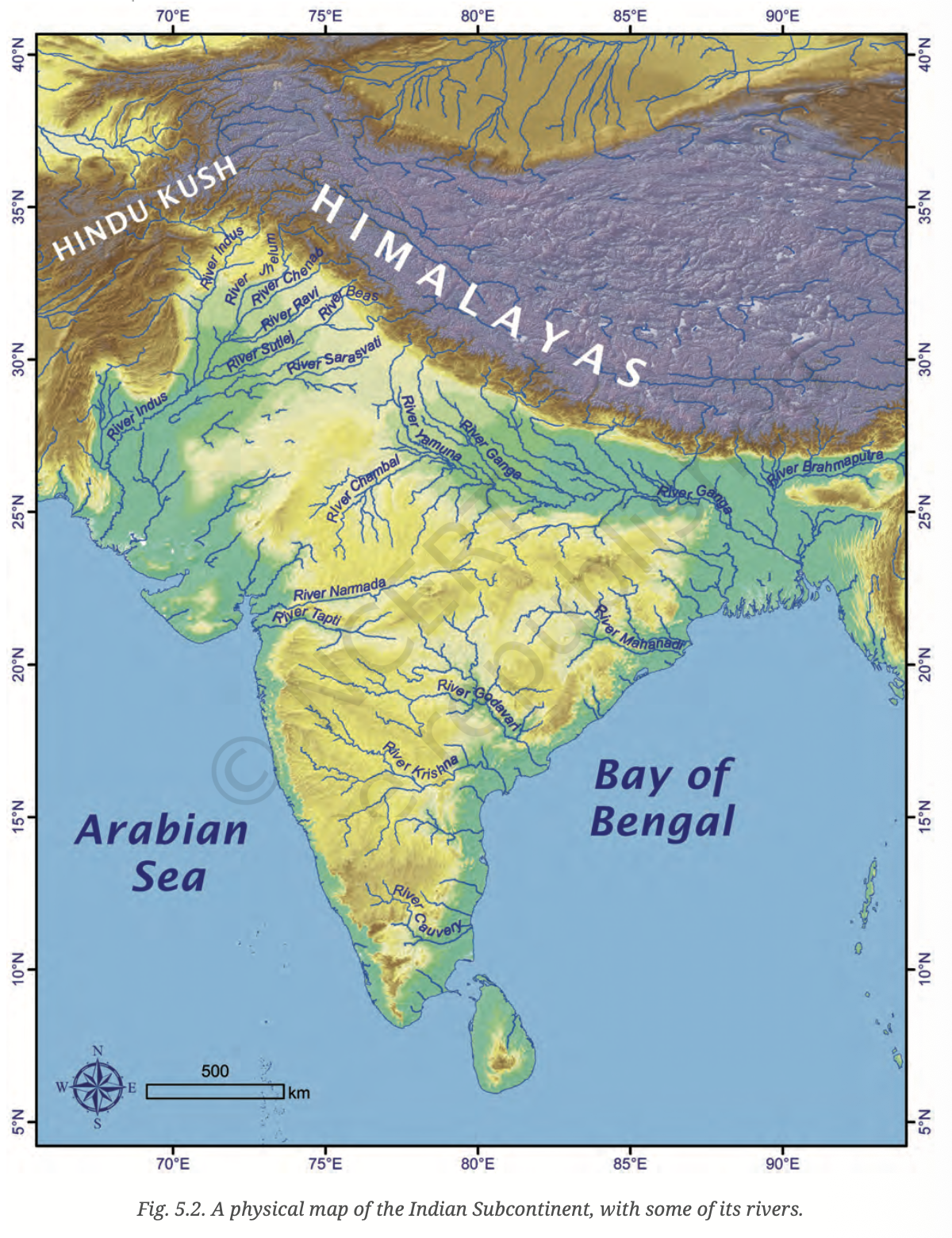
Returning to page 10 and to Fig. 5.2 in Chapter 5 of this textbook, taking the scale to be 2.5 cm = 500 km, calculate the real distance from the estuary of the Narmada River to the estuary of the Ganga river. (Hint: round off your measurement on the map to an easy number.)

Solution
Solution
Given Scale: 2.5 cm = 500 km
Step-by-step Calculation:
-
Step 1: Using a ruler on Fig. 5.2, measure the straight-line distance on the map between the estuary of the Narmada River (it meets the sea near Bharuch in the Gulf of Khambhat) and the estuary of the Ganga River (the Ganga-Brahmaputra delta in West Bengal/Bangladesh).
-
Step 2: The approximate measured distance on the map is about 5 cm (rounding off to an easy number as hinted).
-
Step 3: Apply the scale formula:
Real Distance = (Map Distance ÷ Scale Distance) × Real Scale Value
Real Distance = (5 cm ÷ 2.5 cm) × 500 km
Real Distance = 2 × 500 km
Real Distance = 1000 km
Answer: The real distance from the estuary of the Narmada River to the estuary of the Ganga River is approximately 1000 km.
Note: Your measured map distance may vary slightly depending on the exact points measured. Always round off to the nearest easy number as suggested by the hint.
Why is it 5:30 pm in India when it is 12 pm (noon) in London?
Solution
Solution
Reason: Difference in Longitude and Earth's Rotation
-
The Earth rotates 360° in 24 hours, which means it rotates 15° every hour or 1° every 4 minutes.
-
London is located at 0° longitude (the Prime Meridian).
-
India's Standard Time (IST) is based on 82.5°E longitude (which passes through Mirzapur, near Allahabad).
-
Calculating the time difference:
- Difference in longitude = 82.5° − 0° = 82.5°
- Time difference = 82.5° × 4 minutes = 330 minutes = 5 hours 30 minutes
-
Since India is east of London, the Sun rises earlier in India. Therefore, India's time is ahead of London's time by 5 hours and 30 minutes.
-
So when it is 12:00 noon in London, it is 12:00 + 5:30 = 5:30 pm in India.
Answer: India is located at 82.5°E longitude, which is 82.5° east of the Prime Meridian (0°). Since the Earth rotates 1° every 4 minutes, this 82.5° difference creates a time difference of 5 hours and 30 minutes. Because India is to the east, its time is ahead of London's time by 5 hours 30 minutes.
Why do we need symbols and colours on a map?
Solution
Solution
We need symbols and colours on maps for the following reasons:
-
1. Maps are small representations of large areas: A map shows a huge area (like a country or the world) in a very small space. It is impossible to draw every feature (rivers, mountains, roads, forests) in detail. So symbols are used to represent real features in a simple, compact way.
-
2. Symbols make maps easy to read: Instead of writing long names or drawing detailed pictures, symbols (like a blue line for a river, a small triangle for a mountain peak, or a dotted line for a boundary) make maps quick and clear to understand.
-
3. Colours help distinguish different features: Different colours are used to show different types of information at a glance:
- Blue → Water bodies (rivers, lakes, seas)
- Green → Forests or plains
- Brown/Yellow → Mountains or deserts
- White → Snow-covered areas
- Different colours → Different countries or states
-
4. Universal understanding: Symbols and colours follow standard conventions, so a person from any part of the world can read and understand a map without knowing the local language.
-
5. They save space: A symbol or colour can represent a huge amount of information in a tiny space on the map.
Answer: Symbols and colours are essential on maps because they help represent large, complex features in a small, easy-to-read format. They allow anyone to quickly understand geographical information like terrain, water bodies, and boundaries.
Find out what is present in all eight directions (North, South, East, West, NE, NW, SE, SW) from your home or school.
Solution
Solution
This is an activity-based question. Here is a sample answer for a school in a typical Indian city:
Eight Directions and What is Found:
| Direction | What is Found (Sample) |
|---|---|
| North (N) | A park or playground |
| South (S) | A market or shopping area |
| East (E) | A residential colony |
| West (W) | A hospital or clinic |
| North-East (NE) | A temple or place of worship |
| North-West (NW) | A bus stand or transport hub |
| South-East (SE) | A school or educational institution |
| South-West (SW) | A pond, lake, or open ground |
How to do this activity:
- Step 1: Stand at the entrance of your home or school.
- Step 2: Use a compass (or the position of the rising Sun in the East) to identify the directions.
- Step 3: Look or walk in each of the eight directions and note what you see — buildings, roads, water bodies, open land, etc.
- Step 4: Make a simple diagram or table like the one above.
Note: Your answers will be different based on where your home or school is located. Observe carefully and fill in your own answers.
What is the difference between local time and standard time? Discuss in groups and write an answer in 100 to 150 words.
Solution
Solution
Local Time vs. Standard Time
Local Time is the time determined by the position of the Sun at a specific location. Since the Earth rotates from west to east, the Sun appears at different positions at different longitudes at any given moment. Every place has its own local time based on when the Sun is at its highest point (noon). Even two cities just a few degrees of longitude apart will have slightly different local times.
Standard Time is a uniform time adopted by a country or region to avoid confusion caused by many different local times. Instead of every town following its own local time, a country selects one central meridian and sets all clocks to the time at that meridian. This is called Standard Time.
In India's case:
- India follows Indian Standard Time (IST), based on the 82.5°E meridian (passing near Mirzapur, Uttar Pradesh).
- This single standard time is followed across the entire country, even though India spans from about 68°E to 97°E longitude.
- If local time were used, the difference between the easternmost and westernmost parts of India would be about 1 hour 56 minutes.
Key Difference:
| Local Time | Standard Time |
|---|---|
| Based on the Sun's position at a specific longitude | Based on a chosen central meridian for a region or country |
| Different for every location | Same for everyone in a time zone |
| More accurate astronomically | More practical for daily use |
| Changes with longitude | Fixed for the whole country/zone |
Delhi's latitude is 29°N and Bengaluru's latitude is 13°N; their longitudes are almost the same at 77°E. How much will be the difference in local time between the two cities?
Solution
Solution
Given:
- Delhi: Latitude = 29°N, Longitude = 77°E
- Bengaluru: Latitude = 13°N, Longitude = 77°E
Key Concept:
- Local time depends on longitude, not latitude.
- Latitude tells us how far north or south a place is from the Equator.
- Longitude tells us how far east or west a place is from the Prime Meridian.
- Since time zones and local time are determined by longitude, two places with the same longitude have the same local time, regardless of their latitude.
Calculation:
- Both Delhi and Bengaluru are at 77°E longitude.
- Difference in longitude = 77°E − 77°E = 0°
- Time difference = 0° × 4 minutes = 0 minutes
Answer: Since both Delhi and Bengaluru lie on almost the same meridian (77°E), the difference in their local time is zero (or negligible). Local time is determined by longitude, not latitude, so despite being at very different latitudes (29°N and 13°N), their local times are the same.
Mark the following statements as True or False and explain each with one or two sentences.
Solution
Solution
Statement 1: All parallels of latitude have the same length.
- False.
- The Equator (0°) is the longest parallel of latitude. As we move towards the poles, the parallels of latitude become progressively shorter. The poles (90°N and 90°S) are just single points with zero length.
Statement 2: The length of a meridian of longitude is half of that of the Equator.
- True.
- A meridian of longitude is a semicircle that goes from the North Pole to the South Pole. The Equator is a full circle. Since a semicircle is half of a full circle, the length of any meridian is exactly half the length of the Equator.
Statement 3: The South Pole has a latitude of 90°S.
- True.
- Latitude is measured from the Equator (0°) to the poles (90°). The South Pole is the southernmost point on Earth, located at 90° South latitude, which is written as 90°S.
Statement 4: In Assam, the local time and the IST are identical.
- False.
- Indian Standard Time (IST) is based on the 82.5°E meridian. Assam is located much further east, around 92°E to 96°E. Since Assam's longitude is greater than 82.5°E, its local time is ahead of IST by about 40 minutes to over an hour. Therefore, local time and IST in Assam are not the same.
Statement 5: Lines separating time zones are identical with meridians of longitude.
- False.
- Ideally, time zone boundaries follow meridians of longitude. However, in practice, time zone boundaries are adjusted to follow political and geographical boundaries (like country borders, rivers, or state lines) so that a country or region can share the same time. Therefore, real time zone lines are not always identical with meridians of longitude.
Statement 6: The Equator is also a parallel of latitude.
- True.
- The Equator is the 0° parallel of latitude. It is the largest and most central parallel that divides the Earth into the Northern and Southern Hemispheres. So yes, the Equator is both the reference line for latitude and a parallel of latitude itself.
Solve the crossword puzzle about maps, Earth, and locating places.
Solution
Solution: Crossword Answers
Across:
| Number | Clue | Answer |
|---|---|---|
| 1 Across | Lets you squeeze a huge area into your map | SCALE |
| 4 Across | A convenient sphere | GLOBE |
| 5 Across | The longest parallel of latitude | EQUATOR |
| 6 Across | The place the Prime Meridian is attached to | GREENWICH |
| 8 Across | So convenient to find your way | COMPASS |
| 10 Across | A measure of the distance from the Equator | LATITUDE |
Down:
| Number | Clue | Answer |
|---|---|---|
| 2 Down | A measure of the distance from the Prime Meridian | LONGITUDE |
| 3 Down | These two together allow us to locate a place | COORDINATES |
| 6 Down | What latitudes and longitudes together create | GRID |
| 7 Down | The time we all follow in India | IST (Indian Standard Time) |
| 9 Down | On top of the world | POLE (North Pole) |
| 11 Down | An abbreviation for a line across which the day and date change | IDL (International Date Line) |
Note: The exact placement of letters in the crossword grid should be verified with the textbook's grid layout. The answers provided above match the clues given.