📚StudySolv

Class 6 · Social Science · Exploring Society India and Beyond

Chapter 2: Oceans and Continents

ENHI
0 / 1 exercises

Exercise Questions, activities and projects15 Qs

Q Q2 marks

Q1 Explain the term:

(a) Continent

Solution

Answer: A continent is a large, continuous expanse of land on Earth's surface. There are commonly 7\textbf{7} continents: Africa, Antarctica, Asia, Australia, Europe, North America, and South America.

Explanation

Reference: Chapter 2 – Oceans and Continents, Pages 28 & 34–35\text{Pages 28 \& 34–35}

Key Points:

Continent=Large continuous landmass on Earth’s surface\text{Continent} = \text{Large continuous landmass on Earth's surface}

  • A continent is also called a landmass\textbf{landmass}
  • Most widely adopted count: n=7n = 7 continents
  • Europe ++ Asia == single landmass \Rightarrow called Eurasia\textbf{Eurasia} by geologists
Q Q1 mark

Q1 Explain the term:

(b) Ocean

Solution

Answer: An ocean is a vast body of saltwater. Oceans cover nearly 34\dfrac{3}{4} of the Earth's surface. There are 5 oceans\textbf{5 oceans}, all interconnected.

Explanation

Reference: Chapter 2 – Oceans and Continents, Pages 28 & 31–32\text{Pages 28 \& 31–32}

Earth’s Surface=34Water (Oceans)+14Land (Continents)\text{Earth's Surface} = \underbrace{\frac{3}{4}}_{\text{Water (Oceans)}} + \underbrace{\frac{1}{4}}_{\text{Land (Continents)}}

Order by size (largest to smallest):

Pacific>Atlantic>Indian>Southern>Arctic\text{Pacific} > \text{Atlantic} > \text{Indian} > \text{Southern} > \text{Arctic}

Q Q2 marks

Q1 Explain the term:

(c) Island

Solution

Answer: An island is a piece of land surrounded by water on all sides but smaller than a continent. India has >1300> 1300 islands.

Explanation

Reference: Chapter 2 – Oceans and Continents, Page 37\text{Page 37}

IslandLandmass,Island⊄Continent\text{Island} \subset \text{Landmass},\quad \text{Island} \not\subset \text{Continent}

Island GroupLocation
Andaman & NicobarBay of Bengal
LakshadweepArabian Sea
  • Largest island in the world =Greenland= \textbf{Greenland}
  • Area of GreenlandArea of top 10 largest Indian states\text{Area of Greenland} \approx \text{Area of top 10 largest Indian states}
Q Q2 marks

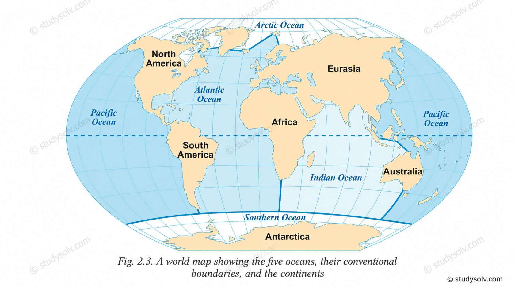
Q2. Let us draw – Without looking at the maps in this chapter, draw the continents free hand on a sheet of paper and colour them. Then compare your drawing with the map of oceans and continents in the chapter.

Solution

Answer: This is a map-drawing activity. Draw all 77 continents from memory and compare with Fig. 2.3\textbf{Fig. 2.3}.

Explanation

Reference: Chapter 2, Page 39\text{Page 39}

Relative sizes (approximate %\% of total land area):

Asia30%>Africa20%>N. America16%>S. America12%>Antarctica9%>Europe7%>Australia6%\text{Asia} \approx 30\% > \text{Africa} \approx 20\% > \text{N. America} \approx 16\% > \text{S. America} \approx 12\% > \text{Antarctica} \approx 9\% > \text{Europe} \approx 7\% > \text{Australia} \approx 6\%

  • Step 1: Sketch the world outline on a blank sheet
  • Step 2: Place and colour each continent in correct position
  • Step 3: Compare your drawing with Fig. 2.3 on Page 32

class 6th chaper 2

Q Q2 marks

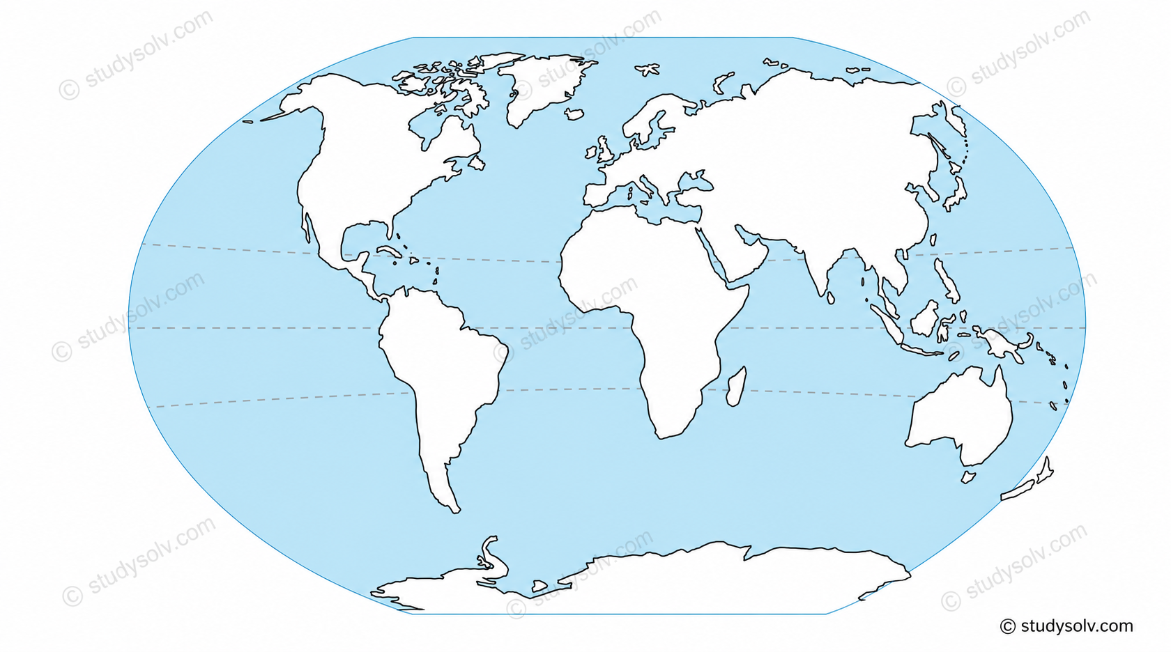
Q3. Let us do – On the outline map of the world given below, label all the continents and oceans.

Solution

Answer: Label 77 continents and 55 oceans in their correct positions. class 6th chaper 2 IMAGE 2

Explanation

Reference: Chapter 2, Pages 32 & 39\text{Pages 32 \& 39}

Continents (n=7)(n = 7):

{ Africa, Antarctica, Asia, Australia, Europe, N. America, S. America }\{\ \text{Africa},\ \text{Antarctica},\ \text{Asia},\ \text{Australia},\ \text{Europe},\ \text{N. America},\ \text{S. America}\ \}

Oceans (n=5)(n = 5):

{ Pacific, Atlantic, Indian, Southern, Arctic }\{\ \text{Pacific},\ \text{Atlantic},\ \text{Indian},\ \text{Southern},\ \text{Arctic}\ \}

Hemisphere distribution:

Northern Hemispheremore land\text{Northern Hemisphere} \Rightarrow \text{more land} Southern Hemispheremore water\text{Southern Hemisphere} \Rightarrow \text{more water}

Q Q2 marks

Q4 (Across 1). "Abundantly produced by the oceans"

Solution

Answer: OXYGEN\textbf{OXYGEN}

Explanation

Reference: Chapter 2, Page 38\text{Page 38}

Oceans produce>50% of Earth’s total oxygen\text{Oceans produce} > 50\%\ \text{of Earth's total oxygen}

  • Produced by marine flora: algae and seaweeds
  • This is why oceans are called "the planet’s lungs"\textbf{"the planet's lungs"}
  • World Oceans Day =June 8= \text{June 8} (designated by the United Nations)
Q Q2 marks

Q4 (Across 3). "A large expanse of landmass"

Solution

Answer: CONTINENT\textbf{CONTINENT}

Explanation

Reference: Chapter 2, Page 28\text{Page 28}

Land covers14 of Earth’s surface\text{Land covers} \approx \frac{1}{4}\ \text{of Earth's surface}

Number of continents={4(Africa-Eurasia, America, Antarctica, Australia)5(Africa, America, Antarctica, Australia, Eurasia)6(Africa, Antarctica, Australia, Eurasia, N. America, S. America)7(most widely used)\text{Number of continents} = \begin{cases} 4 & \text{(Africa-Eurasia, America, Antarctica, Australia)} \\ 5 & \text{(Africa, America, Antarctica, Australia, Eurasia)} \\ 6 & \text{(Africa, Antarctica, Australia, Eurasia, N. America, S. America)} \\ 7 & \text{(most widely used)} \end{cases}

Q Q2 marks

Q4 (Across 6). "A large continent of which India is a part"

Solution

Answer: ASIA\textbf{ASIA}

Explanation

Reference: Chapter 2, Pages 35–36\text{Pages 35–36}

Asia=Largest continent30% of total land area\text{Asia} = \text{Largest continent} \approx 30\%\ \text{of total land area}

Indian Ocean boundaries:{NorthAsiaWestAfricaEastAustralia\text{Indian Ocean boundaries:} \begin{cases} \text{North} & \Rightarrow \text{Asia} \\ \text{West} & \Rightarrow \text{Africa} \\ \text{East} & \Rightarrow \text{Australia} \end{cases}

Q Q2 marks

Q4 (Across 8). "A major source of pollution of the oceans"

Solution

Answer: PLASTIC\textbf{PLASTIC}

Explanation

Reference: Chapter 2, Page 38\text{Page 38}

Plastic waste dumped into oceans=several million tonnes per year\text{Plastic waste dumped into oceans} = \text{several million tonnes per year}

Two major threats to marine life:

Threats=Plastic Pollutionchoking marine life+Overfishingdecline of fish species\text{Threats} = \underbrace{\text{Plastic Pollution}}_{\text{choking marine life}} + \underbrace{\text{Overfishing}}_{\text{decline of fish species}}

Q Q2 marks

Q4 (Across 10). "The coldest continent"

Solution

Answer: ANTARCTICA\textbf{ANTARCTICA}

Explanation

Reference: Chapter 2, Pages 35 & 37\text{Pages 35 \& 37}

Antarcticacoldest, windiest, and driest continent on Earth\text{Antarctica} \Rightarrow \text{coldest, windiest, and driest continent on Earth}

India's Antarctic Research Timeline:

1981Programme begins1983Dakshin Gangotri2 more bases established later1981 \xrightarrow{\text{Programme begins}} 1983 \xrightarrow{\text{Dakshin Gangotri}} \text{2 more bases established later}

  • 40\approx 40 teams of Indian scientists have conducted research there
  • Research focus: evolution of climate and environment
Q Q2 marks

Q4 (Down 2). "The largest island on Earth"

Solution

Answer: GREENLAND\textbf{GREENLAND}

Explanation

Reference: Chapter 2, Page 37\text{Page 37}

Area of Greenlandi=110Area of India’s i-th largest state\text{Area of Greenland} \approx \sum_{i=1}^{10} \text{Area of India's}\ i\text{-th largest state}

  • Located in the North Atlantic Ocean
  • Despite its size, it is classified as an island, not a continent
Q Q2 marks

Q4 (Down 4). "A huge destructive wave from the ocean"

Solution

Answer: TSUNAMI\textbf{TSUNAMI}

Explanation

Reference: Chapter 2, Pages 33–34\text{Pages 33–34}

Tsunamicaused by{Submarine earthquakeVolcanic eruption (ocean floor)\text{Tsunami} \Rightarrow \text{caused by} \begin{cases} \text{Submarine earthquake} \\ \text{Volcanic eruption (ocean floor)} \end{cases}

2004 Indian Ocean Tsunami:

Date=26 December 2004\text{Date} = 26\ \text{December}\ 2004 Cause=Earthquake in Indonesia\text{Cause} = \text{Earthquake in Indonesia} Countries affected=14 (including India)\text{Countries affected} = 14\ \text{(including India)} Lives lost>2,00,000 people\text{Lives lost} > 2{,}00{,}000\ \text{people}

Real-world link: Protected by the Indian Ocean Tsunami Warning System\textbf{Indian Ocean Tsunami Warning System} — a multi-country collaboration involving India and many other nations.

Q Q2 marks

Q4 (Down 5). "The smallest continent"

Solution

Answer: AUSTRALIA\textbf{AUSTRALIA}

Explanation

Reference: Chapter 2, Pages 35–36\text{Pages 35–36}

Size order (smallest to largest):

Australia<Europe<Antarctica<S. America<N. America<Africa<Asia\text{Australia} < \text{Europe} < \text{Antarctica} < \text{S. America} < \text{N. America} < \text{Africa} < \text{Asia}

Australia6% of total land areasmallest continent\text{Australia} \approx 6\%\ \text{of total land area} \Rightarrow \textbf{smallest continent}

Q Q2 marks

Q4 (Down 7). "The largest body of water on Earth"

Solution

Answer: PACIFIC\textbf{PACIFIC} Ocean

Explanation

Reference: Chapter 2, Page 32\text{Page 32}

Size order of oceans (largest to smallest):

Pacific>Atlantic>Indian>Southern>Arctic\text{Pacific} > \text{Atlantic} > \text{Indian} > \text{Southern} > \text{Arctic}

Real fact: The Pacific Ocean alone is larger than all the continents combined, spanning both the Northern and Southern Hemispheres.

Q Q2 marks

Q4 (Down 9). "A landmass (but not a continent) surrounded by the sea"

Solution

Answer: ISLAND\textbf{ISLAND}

Explanation

Reference: Chapter 2, Page 37\text{Page 37}

Island=Landmass surrounded by water on all sides, AreaContinent\text{Island} = \text{Landmass surrounded by water on all sides},\ \text{Area} \ll \text{Continent}

India’s islands>1300\text{India's islands} > 1300

Major groups={Andaman & NicobarBay of BengalLakshadweepArabian Sea\text{Major groups} = \begin{cases} \text{Andaman \& Nicobar} & \Rightarrow \text{Bay of Bengal} \\ \text{Lakshadweep} & \Rightarrow \text{Arabian Sea} \end{cases}

Real fact: Greenland is the largest island on Earth, yet it is still classified as an island and not a continent due to its size relative to recognized continents.